| (insert your NIE or newspaper logo here) |
Weekly Online LessonOnline Lesson ArchiveGrade Level: 5- 8
|
Mapmakers Expecting Changes In Asia
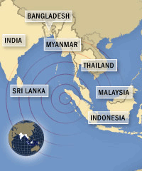 Just days after the
earthquakes and resulting tsunamis socked Indian Ocean coastlines, scientists
announced that the shifts may have also permanently altered the local
geography.
Just days after the
earthquakes and resulting tsunamis socked Indian Ocean coastlines, scientists
announced that the shifts may have also permanently altered the local
geography.
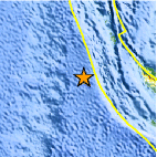
Most scientists believe that the 9.0-magnitude earthquake, and subsequent rumblings -- including the 6.5 quake on Saturday, January 1, 2005 -- are being caused by the movement of the Earth's crust.
Experts have speculated that the boundary between two major tectonic plates -- the Australian and the Eurasian -- slipped 745 miles (1,200 kilometers).
A few days after the first blast, geologists announced that the Indonesian island of Sumatra had moved about 100 feet to the southwest. Later in the week, however, they said that rather than shifting Sumatra's location, the movements more likely raised its elevation.
Until scientists begin documenting changes on the ground there, the exact nature of Earth's rearrangement will remain a mystery. For now, this means that no one owns a truly accurate map of the region.
 Maps
serve many important needs. For millennia, people have depended upon
simple maps to travel from one location to another and keep track of
boundaries. More complex maps illustrate other aspects of a location,
like elevations above and below waterlines, population features, or
environmental variations.
Maps
serve many important needs. For millennia, people have depended upon
simple maps to travel from one location to another and keep track of
boundaries. More complex maps illustrate other aspects of a location,
like elevations above and below waterlines, population features, or
environmental variations.
With the evolution of science and technology, the relative accuracy and precision of maps have steadily improved over time. Graphic artistry is also vital to mapping projects, helping to ensure that data collections are translated into visual aids that people can understand and use.
Professional mapmkers, called cartographers, are typically skilled in several areas of expertise, depending on the types of maps they specialize in.
During this week's lesson, you'll explore the history of maps, meet a few cartographers, and learn how to read and use different maps. You'll also get to test your skills as a GeoSpy!
Cartography: A Way of Life
 You
have probably used or seen many different kinds of maps -- either printed,
on the Web, or one you keep inside your head. Types of maps include
one illustrating your city's streets and landmarks, park trails, county
and state lines, or even one that maps the star constellations.
You
have probably used or seen many different kinds of maps -- either printed,
on the Web, or one you keep inside your head. Types of maps include
one illustrating your city's streets and landmarks, park trails, county
and state lines, or even one that maps the star constellations.
So how long have people been creating and using maps? To find out, let's go visit EOA Scientific Systems and learn All About Maps.
Start exploring Maps: Then and Now by reading the introduction, then jumping into the Interactive Timeline (Shockwave Player required).
Click the forward arrow to move through Mapping the Ancient World. You can also mouse over the words in red to view more information about the related terms and key people.
At the end of that section, click on the next era with the eyeglass to browse through the Middle Ages, then the Renaissance, the Modern World, and Mapping in the Future.
 In
what ways do early maps in different parts of the world reflect what
was important to the local cultures? What kinds of materials did people
use for creating and distributing maps in these different places and
why?
In
what ways do early maps in different parts of the world reflect what
was important to the local cultures? What kinds of materials did people
use for creating and distributing maps in these different places and
why?
What were some of the notable differences in cartography between the different eras? How did developments in science and technology shape the ways in which cartographers and others viewed the world?
How did cartographers collect the information they needed? In what ways did changes in society influence mapmaking?
Now that you've gotten a good overview, let's expand our scope of Cartography. Make sure to have RealPlayer installed to watch the videos.
So, What is Cartography? What types of people are cartographers? What kinds of Skills do cartographers need? Where do cartographers work?
 Have
you ever been in a situation where you had to rely on a cartographer's
skills? What
is the future of cartography? Do you now or might you in
the future use any of the same tools used by cartographers?
Have
you ever been in a situation where you had to rely on a cartographer's
skills? What
is the future of cartography? Do you now or might you in
the future use any of the same tools used by cartographers?
Next, let's get down to the nitty gritty of How Maps Work, starting with Mental Maps. Can you identify any of your own mental maps you use?
What factors influence your Neighborhood Perceptions? What influences Global Perceptions?
Now let's take a look at Map Media, primarily Paper and Digital. How do the two media types compare in terms of how they are created and how usable they are?
 As
you'll soon discover, Map
Concepts and Map
Elements are critical to communicating what a map means
in a universal shorthand sort of way.
As
you'll soon discover, Map
Concepts and Map
Elements are critical to communicating what a map means
in a universal shorthand sort of way.
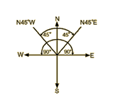
Important concepts you'll learn about include Scale, Distance, Declination & Direction, Grid Systems, and Latitude & Longitude.
Elements of a map -- Legends & Symbols, Color, Compass, and the Title & Source Credit help people interpret what they see, making it as usable as possible.
How do Map Projections help translate the round world into a flat map, and what factors affect your choice of map? Which Map Types, including Topographic Maps, can you find in your classroom, library, or home? What is each map typically used for?
Where in the World Is GeoSpy?
 Now
let's tag along with National Geographic, where you'll join up with
GeoSpy
and train to be a top political geography expert.
Now
let's tag along with National Geographic, where you'll join up with
GeoSpy
and train to be a top political geography expert.
Type in your name, then choose your first assignment.
Warm up with the Continents Game, then challenge yourself with the Countries Game, starting with North America and visiting every continent.
Play the States and Provinces Game, if you have time.
Try comparing these digital, flat maps to topographic maps of the same areas. What kinds of information about a region can you glean from the topographic maps that the GeoSpy political maps don't provide?
Newspaper Activities
Look for different maps in The Salt Lake Tribune. What exactly does each map show? For what reasons do you think the newspaper included each of them? For example, do they accompany news or feature stories? What kinds of information was needed to make the map? Does the map list its sources? How do the artist's choices of color, symbols, title, and other elements add to your understanding of the map? Is the map confusing in any way? If so, what changes could be made to improve it? Can you identify one or more places in the accompanying text that relates to what the map shows?

© Copyright 2005
Learners
Online,
Inc.